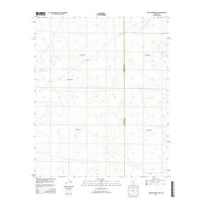
2013 Map of Santa Barbara Lake
USGS Topo · Published 2013About this map
Santa Barbara Lake serves as a central landmark in this high-desert landscape, where the border between Torrance and Guadalupe counties divides the terrain. The map reveals a remote ranching environment characterized by seasonal drainage patterns like San Pablo Draw and the deep relief of Santo Niño Canyon. Settlement is sparse, defined primarily by established agricultural holdings such as George Ranch and Dunlap Ranch. The road network is primarily composed of rural routes like CO Road C076 and Horace Rd, providing access through the various sections of Township 5 and 6 North. This 2013 survey illustrates the enduring rural character of this portion of New Mexico, where topographic features and land divisions remain the primary markers of human presence across the canyons and mesas.
Find a feature on this map
19 named features on this map. Tap any name to fly to it.
Don’t see what you’re looking for? This feature index may not catch every label — zoom into the map to look around manually.
Map Details
Editions of this 2013 Santa Barbara Lake Map
This is the sole edition of this map. No revisions or reprints were ever made.
Other maps of this area

1954 · Fort Sumner
USGS Topo · 1:250,000

1958 · Fort Sumner
USGS Topo · 1:250,000
1978 · George Ranch
USGS Topo · 1:24,000

1978 · Mesa Leon
USGS Topo · 1:24,000

1978 · Santa Barbara Lake
USGS Topo · 1:24,000

1978 · Vaughn
USGS Topo · 1:24,000

1978 · Tejon
USGS Topo · 1:24,000

1978 · Santo Nino Canyon
USGS Topo · 1:24,000

1978 · Encino
USGS Topo · 1:24,000

1978 · Dunlap Ranch
USGS Topo · 1:24,000