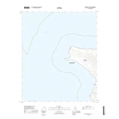
2018 Map of Santa Cruz Island A
USGS Topo · Published 2018About this map
Santa Cruz Island rises from the Pacific Ocean in this 2018 topographic survey, showcasing the western coastal profile of California's largest offshore island. This particular quadrant focuses on the rugged western edge of the landmass, where steep terrain transitions sharply into the sea within the protected boundaries of Channel Islands National Park. The map delineates two primary drainage canyons, Cañada Cervada and Cañada De Los Sauces, which carve through the high ridges toward the coast. These features are critical for understanding the island's unique hydrography and geomorphology. While human settlements are absent on this portion of the island, the map serves as a precise record of the shoreline and elevation contours that define the western reaches of Santa Barbara County's maritime territory.
Find a feature on this map
5 named features on this map. Tap any name to fly to it.
Don’t see what you’re looking for? This feature index may not catch every label — zoom into the map to look around manually.
Map Details
Editions of this 2018 Santa Cruz Island A Map
This is the sole edition of this map. No revisions or reprints were ever made.
Other maps of this area
1943 · Santa Rosa Island East
USGS Topo · 1:24,000
1943 · Santa Cruz Island A
USGS Topo · 1:24,000

1948 · Santa Maria
USGS Topo · 1:250,000

1949 · Los Angeles
USGS Topo · 1:250,000

1949 · Long Beach
USGS Topo · 1:250,000

1955 · Los Angeles
USGS Topo · 1:250,000

1956 · Santa Maria
USGS Topo · 1:250,000

1957 · Long Beach
USGS Topo · 1:250,000

1957 · Santa Maria
USGS Topo · 1:250,000

1958 · Santa Maria
USGS Topo · 1:250,000