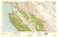
1958 Map of Santa Cruz
USGS Topo · Published 1958About this map
Monterey Bay serves as the focal point of this mid-century survey, where the coastal communities of Santa Cruz and Monterey meet the vast interior of Central California. The landscape transitions from the jagged shoreline at Pacific Grove and Carmel through the fertile Salinas River valley, documented here during a period of significant agricultural and military expansion. Extensive land use is evident in the sprawling Fort Ord Military Reservation and the southern reaches of Hunter Liggett Military Reservation, while the complex irrigation networks of the San Joaquin Valley begin to take shape with the Delta-Mendota Canal and the California Aqueduct.
Find a feature on this map
70 named features on this map. Tap any name to fly to it.
Don’t see what you’re looking for? This feature index may not catch every label — zoom into the map to look around manually.
Map Details
Editions of this 1958 Santa Cruz Map
2 editions found
Other maps of this area

1902 · Santa Cruz
USGS Topo · 1:125,000

1910 · Gonzales
USGS Topo · 1:31,680

1910 · Salinas
USGS Topo · 1:31,680

1910 · Soledad
USGS Topo · 1:31,680

1912 · Salinas
USGS Topo · 1:62,500

1912 · Coalinga
USGS Topo · 1:125,000

1912 · San Ardo
USGS Topo · 1:31,680

1912 · Metz
USGS Topo · 1:31,680

1912 · Mariposa
USGS Topo · 1:125,000

1912 · Capitola
USGS Topo · 1:62,500