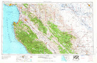
1958 Map of Santa Cruz
USGS Topo · Published 1958About this map
The Monterey Bay coastline and the agricultural corridors of central California are documented here during a period of significant mid-century development. Major military installations, including the Fort Ord Military Reservation and Hunter Liggett Military Reservation, occupy large tracts of the Santa Lucia Range, while the Southern Pacific railroad follows the path of the Salinas River through the heart of the valley.
Find a feature on this map
61 named features on this map. Tap any name to fly to it.
Don’t see what you’re looking for? This feature index may not catch every label — zoom into the map to look around manually.
Map Details
Editions of this 1958 Santa Cruz Map
2 editions found
Other maps of this area

1902 · Santa Cruz
USGS Topo · 1:125,000

1910 · Gonzales
USGS Topo · 1:31,680

1910 · Salinas
USGS Topo · 1:31,680

1910 · Soledad
USGS Topo · 1:31,680

1912 · Salinas
USGS Topo · 1:62,500

1912 · Coalinga
USGS Topo · 1:125,000

1912 · San Ardo
USGS Topo · 1:31,680

1912 · Metz
USGS Topo · 1:31,680

1912 · Mariposa
USGS Topo · 1:125,000

1912 · Capitola
USGS Topo · 1:62,500