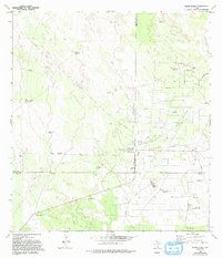
1972 Map of Santa Elena
USGS Topo · Published 1993About this map
Santa Elena serves as the focal point of this South Texas landscape, where the borders of Jim Hogg, Brooks, and Starr counties converge. The area is defined by the extensive Kelsey Bass Oil Field, a network of Oil Wells, and a prominent Pumping Sta that underscore the mid-century energy economy. Beyond the industrial infrastructure, the map reveals a pattern of ranching and remote settlement, notably at La Particion Ranch and the Kelsey Bass Camp.
Find a feature on this map
29 named features on this map. Tap any name to fly to it.
Don’t see what you’re looking for? This feature index may not catch every label — zoom into the map to look around manually.
Map Details
Editions of this 1972 Santa Elena Map
2 editions found
Other maps of this area

1938 · Agua Nueva
USGS Topo · 1:62,500

1938 · Sal Colorada
USGS Topo · 1:62,500

1939 · La Reforma
USGS Topo · 1:62,500

1939 · Encantada
USGS Topo · 1:62,500

1949 · Mc Allen
USGS Topo · 1:250,000

1954 · McAllen
USGS Topo · 1:250,000

1957 · Mc Allen
USGS Topo · 1:250,000

1962 · McAllen
USGS Topo · 1:250,000
1972 · Santa Elena SE
USGS Topo · 1:24,000
1972 · Tacubaya
USGS Topo · 1:24,000