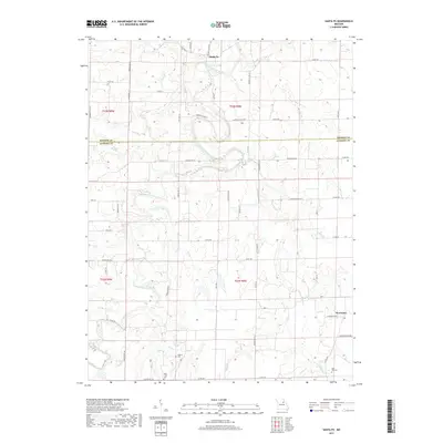
2017 Map of Santa Fe
USGS Topo · Published 2017About this map
South Fork Salt River and its numerous tributaries dominate this landscape on the border of Monroe and Audrain counties. The small settlement of Santa Fe sits in the northern reaches, while Worcester occupies the eastern edge, reflecting the rural character of this agricultural region. Local genealogy is well-preserved through several family-named burial sites, including Eubank Cem, Bean Creek Cem, and Rock Hill Cem, which are scattered among the drainage basins of Littleby Cr and Hazel Cr. The map reveals a complex network of county roads, such as Monroe Co Rd 647 and Audrain Rd 335, that navigate the rolling topography shaped by creeks like Tuttys Cr and Wildcat Cr. The winding paths of Long Br and Elm Br emphasize the importance of water access and drainage in the development of these Missouri townships.
Find a feature on this map
63 named features on this map. Tap any name to fly to it.
Don’t see what you’re looking for? This feature index may not catch every label — zoom into the map to look around manually.
Map Details
Editions of this 2017 Santa Fe Map
This is the sole edition of this map. No revisions or reprints were ever made.
Other maps of this area

1890 · Mexico
USGS Topo · 1:125,000

1932 · Mexico
USGS Topo · 1:62,500

1942 · Wellsville
USGS Topo · 1:62,500

1945 · Florida
USGS Topo · 1:62,500

1945 · Perry
USGS Topo · 1:62,500

1948 · Quincy
USGS Topo · 1:250,000

1956 · Quincy
USGS Topo · 1:250,000
1972 · Mexico East
USGS Topo · 1:24,000
1972 · Molino
USGS Topo · 1:24,000
1972 · Santa Fe
USGS Topo · 1:24,000