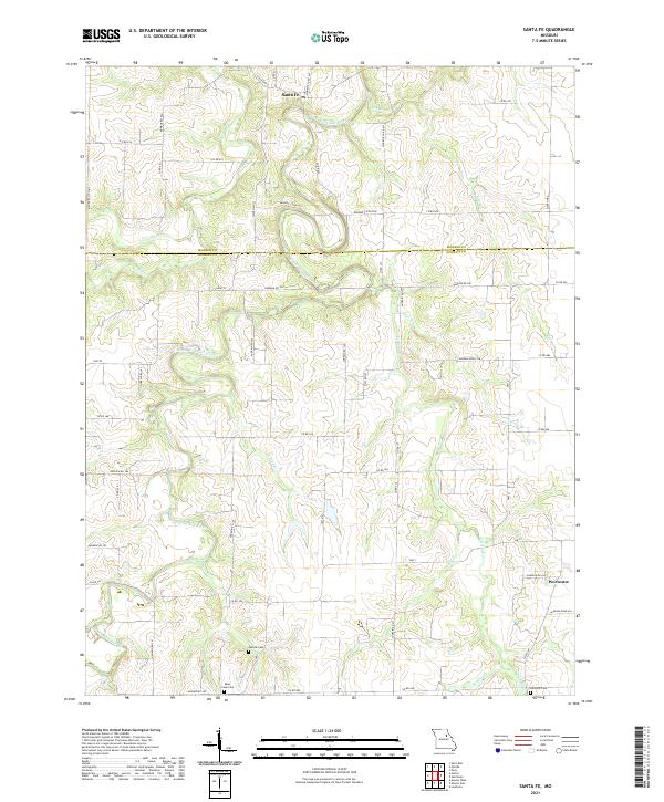
2021 Map of Santa Fe
USGS Topo · Published 2021About this map
The South Fork Salt River meanders deeply across the northern half of this landscape, forming a complex series of oxbow bends and wide bottomlands. The settlement of Santa Fe sits at the northern edge, while the smaller community of Worcester occupies the southeastern corner. This region is defined by a dense network of county roads, such as Monroe Co Rd 611 and Audrain Rd 335, which follow the section lines and ridges between the many creek drainages. Genealogists will find several burial grounds preserved on this map, including Eubank Cem, Bean Creek Cem, and Rock Hill Cem. Numerous tributaries like Littleby Cr, Talleys Br, and Youngs Cr dissect the terrain, showing the drainage patterns that shaped the local agricultural developments and early road placements.
Find a feature on this map
58 named features on this map. Tap any name to fly to it.
Don’t see what you’re looking for? This feature index may not catch every label — zoom into the map to look around manually.
Map Details
Editions of this 2021 Santa Fe Map
This is the sole edition of this map. No revisions or reprints were ever made.
Other maps of this area

1890 · Mexico
USGS Topo · 1:125,000

1932 · Mexico
USGS Topo · 1:62,500

1942 · Wellsville
USGS Topo · 1:62,500

1945 · Florida
USGS Topo · 1:62,500

1945 · Perry
USGS Topo · 1:62,500

1948 · Quincy
USGS Topo · 1:250,000

1956 · Quincy
USGS Topo · 1:250,000
1972 · Mexico East
USGS Topo · 1:24,000
1972 · Molino
USGS Topo · 1:24,000
1972 · Santa Fe
USGS Topo · 1:24,000