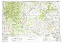
1954 Map of Santa Fe
USGS Topo · Published 1984About this map
Sangre de Cristo Mountains dominate the western horizon of this mid-century New Mexico landscape, rising sharply above the state capital of Santa Fe. The region is defined by a deep history of movement and trade, with the Atchison Topeka and Santa Fe railroad and U.S. 66 threading through the mountain passes and across the high plains. Indigenous heritage remains central to the area, represented by the Nambe Pueblo and Tesuque Pueblo.
Find a feature on this map
124 named features on this map. Tap any name to fly to it.
Don’t see what you’re looking for? This feature index may not catch every label — zoom into the map to look around manually.
Map Details
Editions of this 1954 Santa Fe Map
4 editions found

Other maps of this area

1889 · Las Vegas
USGS Topo · 1:125,000

1889 · Santa Fe
USGS Topo · 1:125,000

1890 · Bernal
USGS Topo · 1:125,000

1891 · Bernal
USGS Topo · 1:125,000

1891 · Las Vegas
USGS Topo · 1:125,000

1892 · San Pedro
USGS Topo · 1:125,000

1892 · Santa Clara
USGS Topo · 1:125,000

1892 · Watrous
USGS Topo · 1:125,000

1892 · Corazon
USGS Topo · 1:125,000

1893 · Las Vegas
USGS Topo · 1:125,000