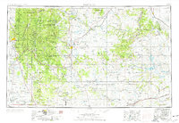
1954 Map of Santa Fe
USGS Topo · Published 1976About this map
The Sangre de Cristo Mountains dominate the western portion of this mid-century landscape, sheltering high-altitude landmarks like Santa Fe Baldy and Truchas Peak. Below the peaks, the state capital of Santa Fe sits at the edge of the Santa Fe National Forest, while the Atchison Topeka and Santa Fe Railroad winds through Glorieta and Lamy. The eastern plains are characterized by broad tablelands such as Yegua Mesa and Mesa Huerfana, eventually descending toward the waters of Conchas Lake.
Find a feature on this map
90 named features on this map. Tap any name to fly to it.
Don’t see what you’re looking for? This feature index may not catch every label — zoom into the map to look around manually.
Map Details
Editions of this 1954 Santa Fe Map
4 editions found

Other maps of this area

1889 · Las Vegas
USGS Topo · 1:125,000

1889 · Santa Fe
USGS Topo · 1:125,000

1890 · Bernal
USGS Topo · 1:125,000

1891 · Bernal
USGS Topo · 1:125,000

1891 · Las Vegas
USGS Topo · 1:125,000

1892 · San Pedro
USGS Topo · 1:125,000

1892 · Santa Clara
USGS Topo · 1:125,000

1892 · Watrous
USGS Topo · 1:125,000

1892 · Corazon
USGS Topo · 1:125,000

1893 · Las Vegas
USGS Topo · 1:125,000