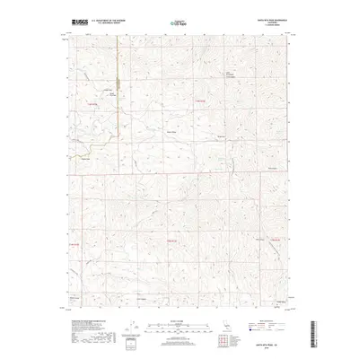
2018 Map of Santa Rita Peak
USGS Topo · Published 2018About this map
Santa Rita Peak serves as a prominent landmark along the jagged divide between Fresno and San Benito counties, where high ridges of the Diablo Range separate the coastal interior from the San Joaquin Valley. The high-altitude terrain is characterized by a network of seasonal water sources and canyons, including the headwaters of the San Benito River and the winding White Creek. Localized topography reveals isolated pockets of level ground such as Adobe Flat and the high-elevation Spanish Lake, which contrast sharply with the steep ascents of Joaquin Ridge and Wright Mountain.
Find a feature on this map
37 named features on this map. Tap any name to fly to it.
Don’t see what you’re looking for? This feature index may not catch every label — zoom into the map to look around manually.
Map Details
Editions of this 2018 Santa Rita Peak Map
This is the sole edition of this map. No revisions or reprints were ever made.
Other maps of this area

1912 · Coalinga
USGS Topo · 1:125,000

1915 · Priest Valley
USGS Topo · 1:125,000

1941 · Priest Valley
USGS Topo · 1:62,500

1943 · New Idria
USGS Topo · 1:62,500

1943 · Joaquin Rocks
USGS Topo · 1:62,500
1944 · Coalinga
USGS Topo · 1:62,500

1944 · Priest Valley
USGS Topo · 1:62,500

1948 · Santa Cruz
USGS Topo · 1:250,000

1955 · Santa Cruz
USGS Topo · 1:250,000
1956 · New Idria
USGS Topo · 1:62,500