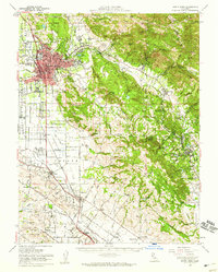
1954 Map of Santa Rosa
USGS Topo · Published 1959About this map
Santa Rosa serves as the bustling hub of this mid-century valley landscape, where the urban grid meets the agricultural reaches of the Petaluma Valley and Bennett Valley. The Northwestern Pacific railroad corridor anchors several outlying communities, including Penngrove and Cotati, while the Cotati Naval Auxiliary Air Station and a nearby Military Reservation reflect the enduring post-war defense presence in the county. Significant institutional footprints are visible at the Sonoma State Home (Eldridge PO) and the Los Guilicos School for Girls.
Find a feature on this map
114 named features on this map. Tap any name to fly to it.
Don’t see what you’re looking for? This feature index may not catch every label — zoom into the map to look around manually.
Map Details
Editions of this 1954 Santa Rosa Map
2 editions found
Other maps of this area

1902 · Napa
USGS Topo · 1:125,000

1914 · Petaluma
USGS Topo · 1:62,500

1916 · Mare Island
USGS Topo · 1:62,500

1916 · Santa Rosa
USGS Topo · 1:62,500

1916 · Point Reyes
USGS Topo · 1:48,000

1918 · Point Reyes
USGS Topo · 1:62,500

1920 · Healdsburg
USGS Topo · 1:62,500

1927 · Calistoga
USGS Topo · 1:62,500

1933 · Healdsburg
USGS Topo · 1:48,000

1935 · Sebastopol
USGS Topo · 1:48,000