
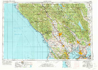
1958 Map of Santa Rosa
USGS Topo · Published 1968About this map
Santa Rosa and the surrounding North Bay counties appear here during a period of transition in the late 1950s and 1960s, showing a landscape defined by its agricultural heritage and growing coastal preservation. The map traces the extensive Northwestern Pacific RR line as it follows the Russian River corridor through Healdsburg and Cloverdale, serving the region's timber and farm economies. Significant historical sites are noted throughout the hills, from the Petaluma Adobe Historical Monument to the coastal Fort Ross State Historical Monument.
Find a feature on this map
244 named features on this map. Tap any name to fly to it.
Don’t see what you’re looking for? This feature index may not catch every label — zoom into the map to look around manually.
Map Details
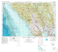
Editions of this 1958 Santa Rosa Map
3 editions found
Other maps of this area

1888 · Marysville
USGS Topo · 1:125,000

1891 · Marysville
USGS Topo · 1:125,000

1894 · Marysville
USGS Topo · 1:125,000

1895 · Marysville
USGS Topo · 1:125,000

1895 · San Francisco
USGS Topo · 1:62,500

1896 · Carquinez Strait
USGS Topo · 1:62,500

1896 · Mt. Diablo
USGS Topo · 1:62,500

1897 · Concord
USGS Topo · 1:62,500

1897 · Tamalpais
USGS Topo · 1:62,500

1898 · Karquines
USGS Topo · 1:62,500