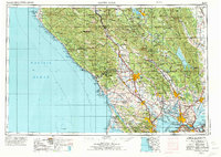
1958 Map of Santa Rosa
USGS Topo · Published 1973About this map
Santa Rosa serves as the inland hub for this mid-century survey of the North Bay and Wine Country, a landscape defined by the drainage of the Russian River and the expanding road networks of Us 101 and Calif 29. The map details a period of significant military and institutional presence, showing the Mare Island Naval Shipyard at Vallejo, the Benicia Arsenal, and the Skaggs Island US Naval Security Group Activity. Coastal reaches from Point Arena down to Point Reyes remain largely rural, anchored by settlements like Bodega Bay and Inverness. This edition records the area before the full suburbanization of the late 20th century, capturing Sonoma State College in its early years and the rail corridors of the Northwestern Pacific RR and Southern Pacific RR that once knit these valley towns together.
Find a feature on this map
148 named features on this map. Tap any name to fly to it.
Don’t see what you’re looking for? This feature index may not catch every label — zoom into the map to look around manually.
Map Details
Editions of this 1958 Santa Rosa Map
3 editions found

Other maps of this area

1888 · Marysville
USGS Topo · 1:125,000

1891 · Marysville
USGS Topo · 1:125,000

1894 · Marysville
USGS Topo · 1:125,000

1895 · Marysville
USGS Topo · 1:125,000

1895 · San Francisco
USGS Topo · 1:62,500

1896 · Carquinez Strait
USGS Topo · 1:62,500

1896 · Mt. Diablo
USGS Topo · 1:62,500

1897 · Concord
USGS Topo · 1:62,500

1897 · Tamalpais
USGS Topo · 1:62,500

1898 · Karquines
USGS Topo · 1:62,500