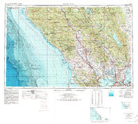
1958 Map of Santa Rosa
USGS Topo · Published 1980About this map
The Russian River and its surrounding valleys anchor this regional study of Northern California’s coastal corridor and wine country. In the years following World War II, the landscape reflects a mix of growing educational hubs like Sonoma State College and established agricultural nodes such as Forestville, Sebastopol, and Napa. The infrastructure of the era is defined by the Northwestern Pacific RR and Southern Pacific RR lines that connect these inland valleys to the industrial and military complex of the San Francisco Bay area, including Hamilton AFB and the Benicia Arsenal.
Find a feature on this map
243 named features on this map. Tap any name to fly to it.
Don’t see what you’re looking for? This feature index may not catch every label — zoom into the map to look around manually.
Map Details
Editions of this 1958 Santa Rosa Map
3 editions found

Other maps of this area

1888 · Marysville
USGS Topo · 1:125,000

1891 · Marysville
USGS Topo · 1:125,000

1894 · Marysville
USGS Topo · 1:125,000

1895 · Marysville
USGS Topo · 1:125,000

1895 · San Francisco
USGS Topo · 1:62,500

1896 · Carquinez Strait
USGS Topo · 1:62,500

1896 · Mt. Diablo
USGS Topo · 1:62,500

1897 · Concord
USGS Topo · 1:62,500

1897 · Tamalpais
USGS Topo · 1:62,500

1898 · Karquines
USGS Topo · 1:62,500