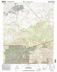
1995 Map of Santa Ynez
USGS Topo · Published 2000About this map
The Santa Ynez Valley transitions from agricultural lowlands to the high ridges of the San Rafael Mountains in this mid-1990s revision. The settlement of Santa Ynez serves as a central hub, flanked by the Santa Ynez Indian Res and a series of prominent land grants including the Cañada de los Pinos College Rancho Grant and Lomas de la Purificacion Grant. This landscape is defined by the winding Santa Ynez River and numerous private holdings such as the Juan y Lolita Ranch and San Lucas Ranch. Further south, the terrain becomes increasingly steep toward Refugio Pass, where the Gaviota Omni Communication Range Sta and Bald Mtn mark the high ground of the Los Padres National Forest. The map captures the complex mix of private ranching, tribal land, and federal forest management characteristic of this Santa Barbara County region.
Find a feature on this map
51 named features on this map. Tap any name to fly to it.
Don’t see what you’re looking for? This feature index may not catch every label — zoom into the map to look around manually.
Map Details
Editions of this 1995 Santa Ynez Map
This is the sole edition of this map. No revisions or reprints were ever made.
Other maps of this area

1902 · Santa Ynez
USGS Topo · 1:125,000

1905 · Santa Ynez
USGS Topo · 1:125,000

1905 · Lompoc
USGS Topo · 1:125,000

1941 · San Rafael Mtn.
USGS Topo · 1:62,500

1942 · Lompoc
USGS Topo · 1:125,000

1942 · Gaviota
USGS Topo · 1:62,500

1942 · Goleta
USGS Topo · 1:62,500

1942 · San Rafael Mtn.
USGS Topo · 1:62,500

1942 · Los Olivos
USGS Topo · 1:62,500

1943 · San Rafael Mtn.
USGS Topo · 1:62,500