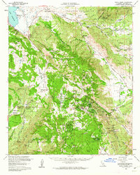
1960 Map of Santa Ysabel
USGS Topo · Published 1962About this map
Julian and the surrounding high country of the Volcan Mountains anchor this 1960 survey of San Diego County's backcountry. The map documents a landscape defined by historic transit and extraction, notably marking the Butterfield Stage Station at Warners Ranch and several active or historical workings like the Washington Mine and Banner Queen Mine. These features illustrate the area's transition from 19th-century gold mining and stagecoach routes to mid-century residential and recreational use, as seen in the development of Kentwood-in-the-Pines and Harrison Park.
Find a feature on this map
103 named features on this map. Tap any name to fly to it.
Don’t see what you’re looking for? This feature index may not catch every label — zoom into the map to look around manually.
Map Details
Editions of this 1960 Santa Ysabel Map
3 editions found
Other maps of this area

1893 · El Cajon
USGS Topo · 1:62,500

1901 · Elcajon
USGS Topo · 1:62,500

1903 · Cuyamaca
USGS Topo · 1:125,000

1903 · Elcajon
USGS Topo · 1:62,500

1903 · Ramona
USGS Topo · 1:125,000

1904 · Indio
USGS Topo · 1:125,000

1904 · Southern California Sheet No. 2
USGS Topo · 1:250,000

1931 · Vallecito
USGS Topo · 1:125,000

1931 · Carrizo
USGS Topo · 1:125,000

1939 · El Cajon
USGS Topo · 1:62,500