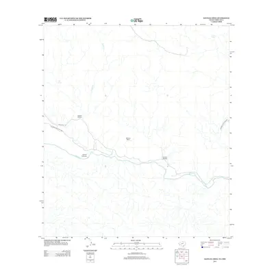
2012 Map of Santana Mesa
USGS Topo · Published 2012About this map
The Rio Grande carves a deep path through this borderland landscape, defining the international boundary between Texas and Chihuahua. This 2012 survey captures a transition in land use, where the protected terrain of Big Bend Ranch State Park meets the arid high ground of Santana Mesa. The presence of Ranch Road 170 provides the primary transit artery through the canyon-scored desert, following the river's course as it passes through Canyon Colorado and Canyon Madera.
Find a feature on this map
11 named features on this map. Tap any name to fly to it.
Don’t see what you’re looking for? This feature index may not catch every label — zoom into the map to look around manually.
Map Details
Editions of this 2012 Santana Mesa Map
This is the sole edition of this map. No revisions or reprints were ever made.
Other maps of this area

1896 · Polvo
USGS Topo · 1:125,000

1903 · Terlingua
USGS Topo · 1:125,000

1904 · Terlingua
USGS Topo · 1:125,000

1931 · Lajitas
USGS Topo · 1:62,500

1959 · Emory Peak
USGS Topo · 1:250,000

1959 · Presidio
USGS Topo · 1:250,000

1965 · Presidio
USGS Topo · 1:250,000

1965 · Emory Peak
USGS Topo · 1:250,000
1971 · Redford SE
USGS Topo · 1:24,000
1971 · The Solitario
USGS Topo · 1:24,000