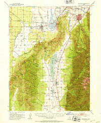
1951 Map of Santaquin
USGS Topo · Published 1953About this map
The agrarian and industrial landscape of southern Utah County and northern Juab County unfolds in this early 1950s survey. The town of Santaquin serves as a focal point, situated at the junction of the Union Pacific and Denver and Rio Grande Western railroads. To the west, the irrigation-dependent settlements of Goshen and Elberta are defined by an extensive network of ditches and Artesian Wells, supporting agriculture in the arid valley.
Find a feature on this map
69 named features on this map. Tap any name to fly to it.
Don’t see what you’re looking for? This feature index may not catch every label — zoom into the map to look around manually.
Map Details
Editions of this 1951 Santaquin Map
3 editions found

Other maps of this area

1885 · Salt Lake
USGS Topo · 1:250,000

1885 · Manti
USGS Topo · 1:250,000

1885 · Sevier Desert
USGS Topo · 1:250,000

1885 · Tooele Valley
USGS Topo · 1:250,000

1895 · Manti
USGS Topo · 1:250,000

1947 · Fivemile Pass
USGS Topo · 1:62,500

1947 · Allens Ranch
USGS Topo · 1:24,000

1948 · Spanish Fork
USGS Topo · 1:24,000

1949 · Eureka
USGS Topo · 1:24,000

1949 · Allens Ranch
USGS Topo · 1:24,000