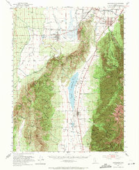
1951 Map of Santaquin
USGS Topo · Published 1971About this map
Santaquin and Mona anchor the agricultural landscape of the Juab Valley in this early 1950s survey, where irrigation networks like the Goshen City DITCH and Strawberry Canal supported the local orchards and farms. The map illustrates a transitional era for the region's transport and utility infrastructure, featuring both the Union Pacific and Denver and Rio Grande Western rail lines alongside the Santaquin Powerhouse. To the east, the dramatic ascent into the Uinta National Forest is marked by landmarks such as Mt Nebo and the Privateer Mine. The central Mona Reservoir and the Burriston Ponds highlight the critical management of water in the arid basin, while the placement of the Genola Ch and Santaquin Cem provides important reference points for those researching the early pioneer settlements of Goshen Valley.
Find a feature on this map
72 named features on this map. Tap any name to fly to it.
Don’t see what you’re looking for? This feature index may not catch every label — zoom into the map to look around manually.
Map Details
Editions of this 1951 Santaquin Map
3 editions found

Other maps of this area

1885 · Salt Lake
USGS Topo · 1:250,000

1885 · Manti
USGS Topo · 1:250,000

1885 · Sevier Desert
USGS Topo · 1:250,000

1885 · Tooele Valley
USGS Topo · 1:250,000

1895 · Manti
USGS Topo · 1:250,000

1947 · Fivemile Pass
USGS Topo · 1:62,500

1947 · Allens Ranch
USGS Topo · 1:24,000

1948 · Spanish Fork
USGS Topo · 1:24,000

1949 · Eureka
USGS Topo · 1:24,000

1949 · Allens Ranch
USGS Topo · 1:24,000