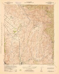
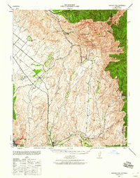
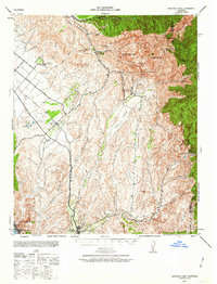
1942 Map of Santiago Peak
USGS Topo · Published 1943About this map
The Santa Ana Mountains dominate this wartime landscape, anchored by the high elevations of Santiago Peak and Modjeska Peak. In the valleys below, the small settlement of Modjeska and the canyon community of Trabuco Oaks reside along the drainage of Santiago Creek and Trabuco Creek. The map documents a critical period of infrastructure before the post-war housing boom, showing the Atchison Topeka and Santa Fe railroad corridor connecting inland points like El Toro to the coastal reach of South Laguna. To the south, the historic mission site of San Juan Capistrano serves as a focal point where San Juan Creek meets Arroyo Trabuco. Strategic military and forest management is evident through the presence of the State Guard Station and the Santiago Lookout, while early recreation is marked by the San Juan Hot Springs in the eastern canyons.
Find a feature on this map
52 named features on this map. Tap any name to fly to it.
Don’t see what you’re looking for? This feature index may not catch every label — zoom into the map to look around manually.
Map Details
Editions of this 1942 Santiago Peak Map
3 editions found
Other maps of this area

1896 · Santa Ana
USGS Topo · 1:62,500

1896 · Anaheim
USGS Topo · 1:62,500

1898 · Anaheim
USGS Topo · 1:62,500

1901 · Southern California Sheet No. 1
USGS Topo · 1:250,000

1901 · Santa Ana
USGS Topo · 1:62,500

1901 · Anaheim
USGS Topo · 1:62,500

1901 · Elsinore
USGS Topo · 1:125,000

1901 · San Luis Rey
USGS Topo · 1:125,000

1901 · Riverside
USGS Topo · 1:62,500

1902 · Capistrano
USGS Topo · 1:125,000