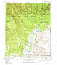
1953 Map of Santo Domingo Pueblo
USGS Topo · Published 1965About this map
Santo Domingo Pueblo and Cochiti Pueblo anchor this mid-century portrait of the Rio Grande valley, where ancient land grants meet modern engineering and industry. The map captures a complex irrigation landscape defined by the Sile Main Canal, Santo Domingo Main Canal, and Cochiti Main Canal, all situated below the site of the Cochiti Dam. To the northwest, the terrain rises sharply toward Bearhead Peak and Cochiti Mesa, revealing industrial activity at the Pumice Mines and the lonely Albemarle (Site). The convergence of the Rio Grande, the Santa Fe River, and Galisteo Creek near the Atchison Topeka and Santa Fe railroad tracks illustrates a vital transportation and water corridor. High desert features like Tent Rocks and the Canada Ranger Sta reflect the transition from river valley to the timbered heights of the Santa Fe National Forest.
Find a feature on this map
76 named features on this map. Tap any name to fly to it.
Don’t see what you’re looking for? This feature index may not catch every label — zoom into the map to look around manually.
Map Details
Editions of this 1953 Santo Domingo Pueblo Map
2 editions found

Other maps of this area

1888 · Bernalillo
USGS Topo · 1:125,000

1889 · Albuquerque
USGS Topo · 1:125,000

1890 · Jemes
USGS Topo · 1:125,000

1892 · San Pedro
USGS Topo · 1:125,000

1892 · Jemes
USGS Topo · 1:125,000

1892 · Santa Clara
USGS Topo · 1:125,000

1893 · Albuquerque
USGS Topo · 1:125,000

1937 · Jemez Springs
USGS Topo · 1:48,000

1943 · Jemez
USGS Topo · 1:62,500

1944 · Jemez Springs
USGS Topo · 1:62,500