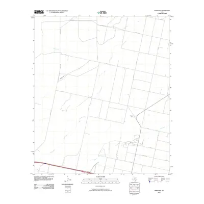
2010 Map of Saragosa
USGS Topo · Published 2010About this map
Saragosa sits at the heart of this West Texas agricultural landscape, where the intersection of water and rail shaped the local economy. The town's grid is defined by E Main St and Parede St, just south of the Saragosa Siding along the rail line. This 2010 survey highlights the vital irrigation infrastructure necessary for life in Reeves County, most notably the Reeves County Water Improvement Canal which cuts across the southern portion of the quadrangle. The surrounding terrain is a network of ephemeral watercourses including Toyah Creek, Canyon Creek, and Cherry Creek, alongside the distinct Adobe Draw. A grid of county roads, such as Co Rd 315 and Co Rd 329, provides access to the ranching and farming tracts that dominate the territory between Ranch Rd 3334 to the north and Ranch Rd 1215 to the south.
Find a feature on this map
23 named features on this map. Tap any name to fly to it.
Don’t see what you’re looking for? This feature index may not catch every label — zoom into the map to look around manually.
Map Details
Editions of this 2010 Saragosa Map
This is the sole edition of this map. No revisions or reprints were ever made.
Other maps of this area

1894 · Fort Davis
USGS Topo · 1:125,000

1897 · Fort Davis
USGS Topo · 1:125,000

1921 · Toyah
USGS Topo · 1:125,000

1954 · Pecos
USGS Topo · 1:250,000

1954 · Fort Stockton
USGS Topo · 1:250,000

1955 · Saragosa
USGS Topo · 1:62,500

1957 · Pecos
USGS Topo · 1:250,000

1958 · Fort Stockton
USGS Topo · 1:250,000

1970 · Florenzo Hill
USGS Topo · 1:24,000
1970 · Verhalen South
USGS Topo · 1:24,000