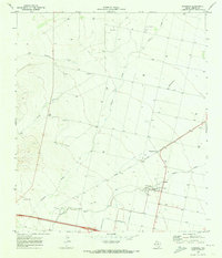
1970 Map of Saragosa
USGS Topo · Published 1974About this map
Saragosa sits at a crossroads of ranching and early irrigation in the Pecos Valley during the early 1970s. The landscape is defined by the vital movement of water through the Water Improvement Canal and the natural drainage of Toyah Creek. This survey captures the infrastructure of the era, from the industrial presence of Saragosa Siding on the Southern rail line to the numerous gravel and borrow pits that supported local construction. A small Cem and a remote Landing Strip illustrate the sparse but organized settlement pattern of Reeves County. Terrain features like Adobe Draw and Cherry Creek highlight the dry-wash topography typical of West Texas, where water management was the primary driver of development and survival in the desert.
Find a feature on this map
15 named features on this map. Tap any name to fly to it.
Don’t see what you’re looking for? This feature index may not catch every label — zoom into the map to look around manually.
Map Details
Editions of this 1970 Saragosa Map
This is the sole edition of this map. No revisions or reprints were ever made.
Other maps of this area

1894 · Fort Davis
USGS Topo · 1:125,000

1897 · Fort Davis
USGS Topo · 1:125,000

1921 · Toyah
USGS Topo · 1:125,000

1954 · Pecos
USGS Topo · 1:250,000

1954 · Fort Stockton
USGS Topo · 1:250,000

1955 · Saragosa
USGS Topo · 1:62,500

1957 · Pecos
USGS Topo · 1:250,000

1958 · Fort Stockton
USGS Topo · 1:250,000

1970 · Florenzo Hill
USGS Topo · 1:24,000
1970 · Verhalen South
USGS Topo · 1:24,000