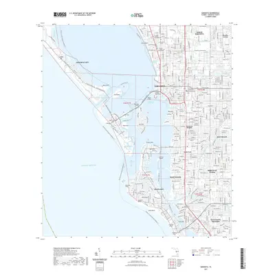
2021 Map of Sarasota
USGS Topo · Published 2021About this map
Sarasota and its barrier islands are shown in extensive detail during the early 2020s, revealing a landscape defined by complex coastal waterways and dense residential development. The city's cultural and civic footprint is anchored by institutions like the Ringling College of Art and Design and the Sarasota County Justice Center downtown. Along the shoreline, the map traces the intricate connections between Bird Key, Saint Armands Key, and Lido Key via the Ringling Bridge, while the larger Siesta Key and Longboat Key front the Gulf of Mexico. Interior residential neighborhoods such as Southgate, Sarasota Heights, and Gulf Gate Estates reflect the city's significant expansion eastward from the historic bayfront. Natural drainage remains visible through winding features like Phillippi Creek and Whitaker Bayou, which persist despite the heavy urbanization of the Sarasota County mainland.
Find a feature on this map
56 named features on this map. Tap any name to fly to it.
Don’t see what you’re looking for? This feature index may not catch every label — zoom into the map to look around manually.
Map Details
Editions of this 2021 Sarasota Map
This is the sole edition of this map. No revisions or reprints were ever made.
Other maps of this area

1943 · Laurel
USGS Topo · 1:24,000

1944 · Bird Keys
USGS Topo · 1:31,680

1944 · Sarasota
USGS Topo · 1:31,680

1944 · Laurel
USGS Topo · 1:31,680

1944 · Lorraine
USGS Topo · 1:31,680

1944 · Bradenton Beach
USGS Topo · 1:31,680

1947 · Bradenton
USGS Topo · 1:24,000

1947 · Bee Ridge
USGS Topo · 1:24,000

1956 · Tampa
USGS Topo · 1:250,000

1959 · Tampa
USGS Topo · 1:250,000