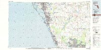
1979 Map of Sarasota
USGS Topo · Published 1980About this map
The Gulf Coast of Florida transitions from the developed barrier islands of Anna Maria Island and Longboat Key to the interior wetlands of the Myakka River basin during the late 1970s. Urban expansion is visible in the corridor between Bradenton and Sarasota, reaching southward through Venice and toward the growing planned communities of North Port and Port Charlotte. Transportation infrastructure like the Sunshine Skyway and the Seaboard Coast Line railroad support this coastal growth, while the Sarasota-Bradenton Airport marks the hub of regional travel. To the east, the landscape remains dominated by conservation and ranching, anchored by the expansive Myakka River State Park and Lake Myakka. This map details the complex shoreline of Sarasota Bay and Little Sarasota Bay, where the interplay of keys, passes like Midnight Pass, and inland drainages such as Cow Pen Slough define the region's geography.
Find a feature on this map
76 named features on this map. Tap any name to fly to it.
Don’t see what you’re looking for? This feature index may not catch every label — zoom into the map to look around manually.
Map Details
Editions of this 1979 Sarasota Map
This is the sole edition of this map. No revisions or reprints were ever made.
Other maps of this area

1921 · Fort De Soto
USGS Topo · 1:62,500

1943 · Laurel
USGS Topo · 1:24,000

1944 · Egmont Key
USGS Topo · 1:31,680

1944 · Bird Keys
USGS Topo · 1:31,680

1944 · Sarasota
USGS Topo · 1:31,680

1944 · Anna Maria
USGS Topo · 1:31,680

1944 · Rye
USGS Topo · 1:31,680

1944 · Lower Myakka Lake
USGS Topo · 1:31,680

1944 · Myakka River
USGS Topo · 1:31,680

1944 · Verna
USGS Topo · 1:31,680