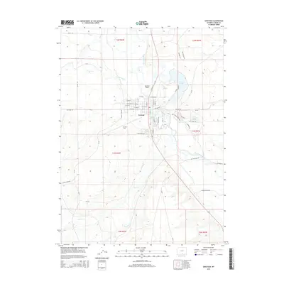
2015 Map of Saratoga
USGS Topo · Published 2015About this map
Saratoga serves as a vital hub in the high-elevation basin of Carbon County, Wyoming, defined by its relationship with the North Platte River. This landscape is heavily shaped by an intricate network of water management, visible in the numerous irrigation channels such as Hugus Mullison Ditch and Lower Ditch. The river itself creates distinct geographic features like Mullison Island and the marshy Hot Slough. To the north, Saratoga Lake and Saratoga Hot Springs underscore the area's role as a thermal and recreational destination. Aviation and transport are grounded at Shively Field south of the town center, while the surrounding terrain is marked by a transition from the structured streets of the village to the expansive cattle-ranching and agricultural lands of the Wyoming high plains, including the drainages of Jack Cr and Spring Cr.
Find a feature on this map
65 named features on this map. Tap any name to fly to it.
Don’t see what you’re looking for? This feature index may not catch every label — zoom into the map to look around manually.
Map Details
Editions of this 2015 Saratoga Map
This is the sole edition of this map. No revisions or reprints were ever made.
Other maps of this area

1893 · Fort Steele
USGS Topo · 1:125,000

1939 · Saratoga
USGS Topo · 1:125,000

1954 · Rawlins
USGS Topo · 1:250,000

1955 · Overland
USGS Topo · 1:24,000

1955 · Overland Crossing
USGS Topo · 1:24,000

1955 · Oberg Ranch
USGS Topo · 1:24,000

1958 · Rawlins
USGS Topo · 1:250,000
1961 · Finley Reservoir
USGS Topo · 1:24,000
1961 · Saratoga
USGS Topo · 1:24,000
1961 · Cow Creek Ranch
USGS Topo · 1:24,000