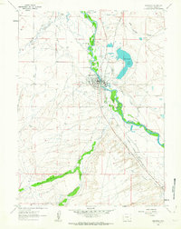
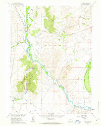
1961 Map of Saratoga
USGS Topo · Published 1963About this map
Saratoga occupies a strategic bend of the North Platte River in this early 1960s study, defined by a complex network of irrigation ditches that support the high plains ranching economy. The town's layout is centered around the Union Pacific rail line and the geothermal Hot Springs, which helped establish the area as a regional destination. The landscape is carved by a legacy of water management, evidenced by the numerous named channels like the Mullison Ditch and the Davis Folsom and Brewery Ditch.
Find a feature on this map
34 named features on this map. Tap any name to fly to it.
Don’t see what you’re looking for? This feature index may not catch every label — zoom into the map to look around manually.
Map Details
Editions of this 1961 Saratoga Map
2 editions found
Other maps of this area

1893 · Fort Steele
USGS Topo · 1:125,000

1939 · Saratoga
USGS Topo · 1:125,000

1954 · Rawlins
USGS Topo · 1:250,000

1955 · Overland
USGS Topo · 1:24,000

1955 · Overland Crossing
USGS Topo · 1:24,000

1955 · Oberg Ranch
USGS Topo · 1:24,000

1958 · Rawlins
USGS Topo · 1:250,000
1961 · Finley Reservoir
USGS Topo · 1:24,000
1961 · Cow Creek Ranch
USGS Topo · 1:24,000
1961 · Cow Creek
USGS Topo · 1:24,000