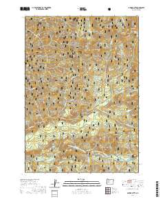
2020 Map of Sardine Butte
USGS Topo · Published 2020About this map
The North Fork Middle Fork Willamette Wild and Scenic River defines the southern portion of this landscape within the Willamette National Forest. This 2020 survey highlights the intricate drainage network of the Western Cascades, where the North Fork Middle Fork Willamette River is fed by numerous tributaries including Christy Cr, Cedar Cr, and Rooster Cr. Small, relatively level openings like Christy Flats and Major Prairie provide a contrast to the surrounding ridges and peaks. Higher elevations are marked by prominent landforms such as Sardine Butte, Ingram Butte, and Battle Peak. Along the river corridor, the N Fork Segment #4 trail follows the water near distinctive landmarks like Buffalo Rock and the steep terrain of Devils Canyon. The map records a modern state of federal forest management, showing a complex web of service roads accessing timberlands and remote hydrologic features like Salt Springs.
Find a feature on this map
47 named features on this map. Tap any name to fly to it.
Don’t see what you’re looking for? This feature index may not catch every label — zoom into the map to look around manually.
Map Details
Editions of this 2020 Sardine Butte Map
This is the sole edition of this map. No revisions or reprints were ever made.
Other maps of this area

1925 · Waldo Lake
USGS Topo · 1:125,000

1934 · Mc Kenzie Bridge
USGS Topo · 1:96,000

1940 · Mc Kenzie Bridge
USGS Topo · 1:125,000

1953 · Salem
USGS Topo · 1:250,000

1954 · Salem
USGS Topo · 1:250,000

1955 · Chucksney Mtn
USGS Topo · 1:62,500

1955 · Blue River
USGS Topo · 1:62,500

1955 · Mc Kenzie Bridge
USGS Topo · 1:62,500

1956 · Sardine Butte
USGS Topo · 1:62,500

1958 · Roseburg
USGS Topo · 1:250,000