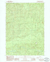
1986 Map of Sardine Butte
USGS Topo · Published 1986About this map
Willamette National Forest encompasses the vast majority of this mid-1980s topographical survey, defining a landscape of high ridges and deep drainage basins in Lane County. The southern portion of the map is dominated by the confluence of major waterways, specifically where the North Fork Middle Fork Willamette River meets the Middle Fork Willamette River. This area serves as a primary recreational and resource hub, evidenced by the Kiahane Campground and numerous quarries and borrow pits scattered throughout the timberlands. Notable high points like Sardine Butte, Ingram Butte, and Battle Peak anchor the surveying grid, while the broad, relatively level Christy Flats offers a rare break in the steep elevations. A complex network of creeks including Sardine Creek, Christy Creek, and Quartz Creek creates a highly dissected terrain, reflecting the intense hydraulic activity of the Western Cascades.
Find a feature on this map
41 named features on this map. Tap any name to fly to it.
Don’t see what you’re looking for? This feature index may not catch every label — zoom into the map to look around manually.
Map Details
Editions of this 1986 Sardine Butte Map
This is the sole edition of this map. No revisions or reprints were ever made.
Other maps of this area

1925 · Waldo Lake
USGS Topo · 1:125,000

1934 · Mc Kenzie Bridge
USGS Topo · 1:96,000

1940 · Mc Kenzie Bridge
USGS Topo · 1:125,000

1953 · Salem
USGS Topo · 1:250,000

1954 · Salem
USGS Topo · 1:250,000

1955 · Chucksney Mtn
USGS Topo · 1:62,500

1955 · Blue River
USGS Topo · 1:62,500

1955 · Mc Kenzie Bridge
USGS Topo · 1:62,500

1956 · Sardine Butte
USGS Topo · 1:62,500

1958 · Roseburg
USGS Topo · 1:250,000