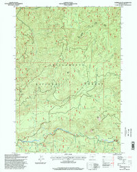
1997 Map of Sardine Butte
USGS Topo · Published 1998About this map
The Willamette National Forest dominates this 1990s terrain, revealing a landscape defined by the intricate drainage systems of the Cascade Range. The North Fork Middle Fork Willamette River winds through the southern portion of the quadrangle, joined by numerous tributaries such as Christy Creek and Sardine Creek. Steep elevations are marked by prominent summits like Sardine Butte, Ingram Butte, and Buffalo Peak, while the relatively level expanse of Christy Flats offers a distinct geographic break in the timbered slopes. Along the river valley, the Robert Aufderheide Memorial Drive Scenic Byway provides the primary corridor for movement. The map also documents industrial activity in the region through numerous quarries scattered across the ridges, and notes natural clearings like Major Prairie, which stand in contrast to the surrounding forest cover.
Find a feature on this map
38 named features on this map. Tap any name to fly to it.
Don’t see what you’re looking for? This feature index may not catch every label — zoom into the map to look around manually.
Map Details
Editions of this 1997 Sardine Butte Map
This is the sole edition of this map. No revisions or reprints were ever made.
Other maps of this area

1925 · Waldo Lake
USGS Topo · 1:125,000

1934 · Mc Kenzie Bridge
USGS Topo · 1:96,000

1940 · Mc Kenzie Bridge
USGS Topo · 1:125,000

1953 · Salem
USGS Topo · 1:250,000

1954 · Salem
USGS Topo · 1:250,000

1955 · Chucksney Mtn
USGS Topo · 1:62,500

1955 · Blue River
USGS Topo · 1:62,500

1955 · Mc Kenzie Bridge
USGS Topo · 1:62,500

1956 · Sardine Butte
USGS Topo · 1:62,500

1958 · Roseburg
USGS Topo · 1:250,000