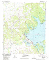
1982 Map of Sardis Dam
USGS Topo · Published 1982About this map
Sardis Dam stands as the central engineering feat of this Panola County landscape, holding the waters of Sardis Lake above the Little Tallahatchie River. The 1982 topography reveals a region defined by modern recreation and older rural foundations, where the John W Kyle State Park and numerous public use areas like Moccasin Point and Beach Point flank the reservoir's edge. This layer of 20th-century development overlies a network of traditional community landmarks, including Simon Chapel No 1, Union Ch, and several family burial grounds such as Liberty Cem and Belmont Cem. The map illustrates the careful management of the river valley, showing the intricate system of spillways, a Gaging Station, and drainage features like Patton Creek and Clarendon Creek that navigate the ridges and lowlands surrounding the massive earth-fill dam.
Find a feature on this map
60 named features on this map. Tap any name to fly to it.
Don’t see what you’re looking for? This feature index may not catch every label — zoom into the map to look around manually.
Map Details
Editions of this 1982 Sardis Dam Map
This is the sole edition of this map. No revisions or reprints were ever made.
Other maps of this area

1940 · Oxford
USGS Topo · 1:62,500

1943 · Oxford
USGS Topo · 1:62,500

1944 · Senatobia
USGS Topo · 1:62,500

1944 · Tyro
USGS Topo · 1:62,500

1952 · Sardis
USGS Topo · 1:62,500

1953 · Sardis
USGS Topo · 1:62,500

1956 · Tupelo
USGS Topo · 1:250,000

1958 · Tupelo
USGS Topo · 1:250,000
1971 · Tyro
USGS Topo · 1:24,000
1975 · Senatobia SW
USGS Topo · 1:24,000