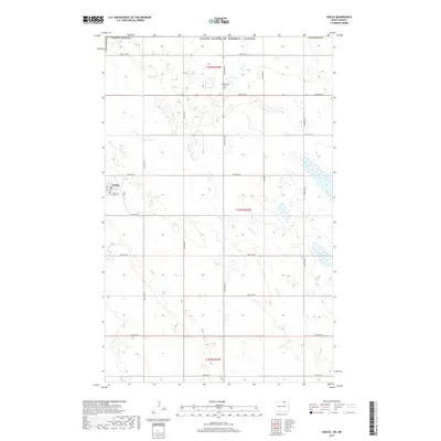
2017 Map of Sarles
USGS Topo · Published 2017About this map
Sarles anchors this northern Cavalier County landscape, situated directly south of the United States / Canada international boundary. The settlement is organized along a grid including Sawyer St, while the surrounding prairie is partitioned by a network of sectional roads such as Townline Rd and 109th St NE. This 2017 survey reflects the persistent agricultural character of the Red River Valley region, where drainage is primarily managed through seasonal watercourses like Cypress Cr. To the north, the Woodbridge Cem serves as a significant marker for genealogical research, located amidst a landscape characterized by numerous small wetlands and glacial depressions typical of the high plains. The intersection of modern county routes and older township lines highlights the enduring township-and-range survey system that has defined North Dakota's land use for over a century.
Find a feature on this map
20 named features on this map. Tap any name to fly to it.
Don’t see what you’re looking for? This feature index may not catch every label — zoom into the map to look around manually.
Map Details
Editions of this 2017 Sarles Map
This is the sole edition of this map. No revisions or reprints were ever made.
Other maps of this area

1953 · Devils Lake
USGS Topo · 1:250,000

1956 · Devils Lake
USGS Topo · 1:250,000

1969 · Rock Lake NE
USGS Topo · 1:24,000

1970 · Sarles NE
USGS Topo · 1:24,000

1970 · Calvin
USGS Topo · 1:24,000

1970 · Sarles SE
USGS Topo · 1:24,000

1970 · Sarles
USGS Topo · 1:24,000

1970 · Rock Lake SE
USGS Topo · 1:24,000

1985 · Langdon
USGS Topo · 1:100,000

1985 · Rock Lake
USGS Topo · 1:100,000