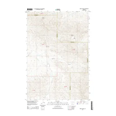
2014 Map of Sarpy School
USGS Topo · Published 2014About this map
The Little Wolf Mountains dominate this high-plains landscape where the borders of Big Horn, Rosebud, and Treasure counties converge. In the early 21st century, this area remains a sparse network of ranch roads and drainages, centered around the Sarpy School landmark. This rural hub is positioned near the junction of Fox Ridge Rd and Sarpy Basin Rd, providing a vital point of reference in an otherwise open terrain. The topography is defined by significant elevation changes, from the heights of Red Butte to the winding depths of Harris Canyon. Water is carved into the land through the seasonal flow of E Fork Sarpy Cr and Black Hawk Cr, which dictate the movement of both local travel and livestock through the basin.
Find a feature on this map
18 named features on this map. Tap any name to fly to it.
Don’t see what you’re looking for? This feature index may not catch every label — zoom into the map to look around manually.
Map Details
Editions of this 2014 Sarpy School Map
This is the sole edition of this map. No revisions or reprints were ever made.
Other maps of this area

1954 · Hardin
USGS Topo · 1:250,000

1957 · Hardin
USGS Topo · 1:250,000

1958 · Hardin
USGS Topo · 1:250,000

1958 · Chalky Point
USGS Topo · 1:24,000

1958 · Black Spring
USGS Topo · 1:24,000

1967 · Jeans Fork NE
USGS Topo · 1:24,000

1971 · Trail Creek School
USGS Topo · 1:24,000

1971 · Mc Clure Creek
USGS Topo · 1:24,000

1971 · Rough Draw
USGS Topo · 1:24,000
1971 · Sarpy School
USGS Topo · 1:24,000