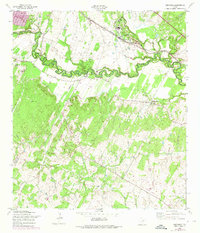
1958 Map of Saspamco
USGS Topo · Published 1975About this map
The San Antonio River carves a serpentine path through this 1958 survey, defining the rural borderlands between Bexar Co and Wilson Co. The landscape is dominated by the tight meanders of the river and its tributaries, including Calaveras Creek and Martana Creek. Industry and transport are central to the area's development, evidenced by the Southern Pacific railroad line that serves the settlement of Saspamco. The name Saspamco itself is an acronym for the San Antonio Sewer Pipe Manufacturing Company, which utilized local clay deposits found in the surrounding terrain.
Find a feature on this map
14 named features on this map. Tap any name to fly to it.
Don’t see what you’re looking for? This feature index may not catch every label — zoom into the map to look around manually.
Map Details
Editions of this 1958 Saspamco Map
2 editions found
Other maps of this area

1936 · Floresville
USGS Topo · 1:62,500

1953 · Elmendorf
USGS Topo · 1:24,000

1953 · Southton
USGS Topo · 1:24,000

1954 · San Antonio
USGS Topo · 1:250,000

1957 · San Antonio
USGS Topo · 1:250,000

1958 · Losoya
USGS Topo · 1:24,000

1958 · La Vernia SW
USGS Topo · 1:24,000

1958 · Saspamco
USGS Topo · 1:24,000
1961 · Dewees
USGS Topo · 1:24,000
1961 · Floresville
USGS Topo · 1:24,000