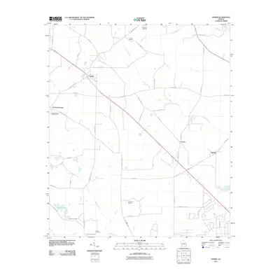
2011 Map of Sasser
USGS Topo · Published 2011About this map
The town of Sasser serves as the focal point of this Terrell County landscape, where the agricultural traditions of Southwest Georgia are etched into a network of country roads. Small settlements and rural hubs such as Chickasawhatchee, Armena, and Oakland are connected by significant local thoroughfares, including the Florida Short Rte and Chain Gang Rd. This region is defined by its many drainages, with Foultown Creek, Kiokee Creek, and Rock Hole Creek winding through the terrain toward Albany Lake and the Albany Lake Dam. Genealogists will find significant value in the documentation of local burial grounds, including the Macedonia Cemetery, Huckby Cemetery, and the Chickasawhatchee Baptist Cemetery. The presence of the Ayresport Airport and the labeling of specific family-named routes like Billy Martin Rd and Hattie Albritton Rd reflect the enduring personal and community history of the area.
Find a feature on this map
52 named features on this map. Tap any name to fly to it.
Don’t see what you’re looking for? This feature index may not catch every label — zoom into the map to look around manually.
Map Details
Editions of this 2011 Sasser Map
This is the sole edition of this map. No revisions or reprints were ever made.
Other maps of this area

1953 · Dothan
USGS Topo · 1:250,000

1954 · Dothan
USGS Topo · 1:250,000

1955 · Dothan
USGS Topo · 1:250,000

1956 · Albany West
USGS Topo · 1:24,000

1956 · Sasser
USGS Topo · 1:62,500

1956 · Albany
USGS Topo · 1:62,500

1956 · Leslie
USGS Topo · 1:62,500

1973 · Chickasawhatchee
USGS Topo · 1:24,000

1973 · Sasser
USGS Topo · 1:24,000

1973 · Pretoria
USGS Topo · 1:24,000