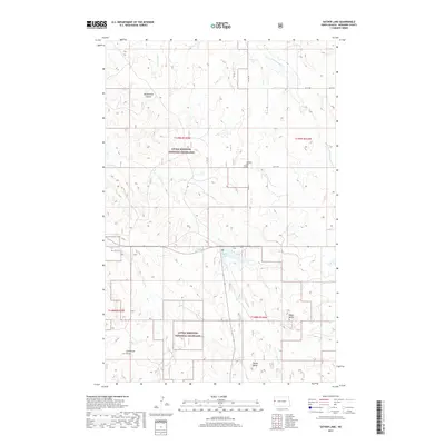
2017 Map of Sather Lake
USGS Topo · Published 2017About this map
Little Missouri National Grassland dominates this portion of McKenzie County, where the high plains transition into the breaks and coulees of western North Dakota. The landscape is defined by its drainages, including the headwaters of Johntown Cr and W Br Charbonneau Cr in the north, and the branching reaches of Horse Cr and Alkali Cr to the south. Centrally located, Sather Lake and the adjacent Sather Reservoir provide a concentrated point of water in an otherwise arid expanse of grassland and buttes.
Find a feature on this map
21 named features on this map. Tap any name to fly to it.
Don’t see what you’re looking for? This feature index may not catch every label — zoom into the map to look around manually.
Map Details
Editions of this 2017 Sather Lake Map
This is the sole edition of this map. No revisions or reprints were ever made.
Other maps of this area

1953 · Watford City
USGS Topo · 1:250,000

1957 · Watford City
USGS Topo · 1:250,000

1967 · Watford City
USGS Topo · 1:250,000

1972 · Alexander
USGS Topo · 1:24,000

1972 · Horse Creek School
USGS Topo · 1:24,000

1972 · Moline School
USGS Topo · 1:24,000

1972 · Charbonneau
USGS Topo · 1:24,000
1972 · Phillip Spring
USGS Topo · 1:24,000

1972 · Sheep Creek
USGS Topo · 1:24,000

1972 · Sather Lake
USGS Topo · 1:24,000