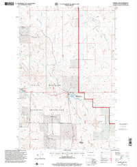
1997 Map of Sather Lake
USGS Topo · Published 2001About this map
Little Missouri National Grassland dominates the western reaches of McKenzie County in this late 1990s survey, representing a vast expanse of public range land punctuated by family-run ranching operations. The presence of Greenwood Ranch and Severson Ranch underscores the area's ongoing cattle-raising legacy, while the Highland Cem near the center of the sheet serves as a quiet marker of earlier settlement eras.
Find a feature on this map
22 named features on this map. Tap any name to fly to it.
Don’t see what you’re looking for? This feature index may not catch every label — zoom into the map to look around manually.
Map Details
Editions of this 1997 Sather Lake Map
This is the sole edition of this map. No revisions or reprints were ever made.
Other maps of this area

1953 · Watford City
USGS Topo · 1:250,000

1957 · Watford City
USGS Topo · 1:250,000

1967 · Watford City
USGS Topo · 1:250,000

1972 · Alexander
USGS Topo · 1:24,000

1972 · Horse Creek School
USGS Topo · 1:24,000

1972 · Moline School
USGS Topo · 1:24,000

1972 · Charbonneau
USGS Topo · 1:24,000
1972 · Phillip Spring
USGS Topo · 1:24,000

1972 · Sheep Creek
USGS Topo · 1:24,000

1972 · Sather Lake
USGS Topo · 1:24,000