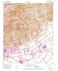
1951 Map of Saticoy
USGS Topo · Published 1986About this map
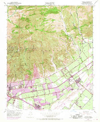
The agricultural and industrial transition of mid-century Ventura County is clearly visible on this 1951 sheet, centered on the Santa Clara River valley. The citrus industry is anchored by Limoneira in the northeast, while the southern landscape is defined by the Southern Pacific rail line and established communities like Saticoy and Montalvo. The map illustrates the varied land uses of the era, from the active Oil Wells in the foothills to the Gravel Pit operations near the riverbed. Education and community life are represented by several sites, including Ventura College, Mound School, and Olive Lands School. Notable cultural markers of the period include a Drive-in Theatre and the prominent Ivy Lawn Cemetery. The drainage patterns are meticulously detailed through numerous named barrancas, such as Arundell Barranca and Harmon Barranca, which carve through the Ex Mission San Buenaventura land grant.
Find a feature on this map
46 named features on this map. Tap any name to fly to it.
Don’t see what you’re looking for? This feature index may not catch every label — zoom into the map to look around manually.
Map Details
Editions of this 1951 Saticoy Map
5 editions found
Other maps of this area

1903 · Santa Paula
USGS Topo · 1:62,500

1904 · Ventura
USGS Topo · 1:62,500

1904 · Hueneme
USGS Topo · 1:62,500

1941 · Ventura
USGS Topo · 1:62,500

1942 · Santa Paula
USGS Topo · 1:62,500

1942 · Hueneme
USGS Topo · 1:62,500

1943 · Hueneme
USGS Topo · 1:62,500

1947 · Santa Paula
USGS Topo · 1:62,500

1949 · Los Angeles
USGS Topo · 1:250,000

1949 · Oxnard
USGS Topo · 1:24,000