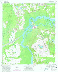
1968 Map of Satsuma
USGS Topo · Published 1981About this map
The ST Johns River dominates this Putnam County landscape, weaving through a complex network of wetlands and islands. Along its eastern banks, established settlements like Satsuma and Nashua follow the corridor of the Seaboard Coast Line railroad. The map documents a pivotal moment in Florida's civil engineering history, clearly showing the western terminus of the Florida Barge Canal and the St Johns Lock where they meet the river. This industrial infrastructure contrasts with the surrounding natural features, such as the Seven Sisters Islands and the expansive Murphy Island, which is carved out by Murphy Creek and Dunns Creek. Local genealogy and community landmarks are well-represented by the Satsuma Cem and Peniel Cem, alongside rural congregations at Trinity Ch and Mt Zion Ch.
Find a feature on this map
46 named features on this map. Tap any name to fly to it.
Don’t see what you’re looking for? This feature index may not catch every label — zoom into the map to look around manually.
Map Details
Editions of this 1968 Satsuma Map
4 editions found
Other maps of this area

1912 · Palatka
USGS Topo · 1:48,000

1915 · Palatka
USGS Topo · 1:62,500

1915 · Interlachen
USGS Topo · 1:48,000

1916 · Interlachen
USGS Topo · 1:62,500

1944 · Interlachen
USGS Topo · 1:62,500

1949 · Baywood
USGS Topo · 1:24,000

1949 · Rodman
USGS Topo · 1:24,000

1949 · Interlachen
USGS Topo · 1:62,500

1954 · Daytona Beach
USGS Topo · 1:250,000

1958 · Daytona Beach
USGS Topo · 1:250,000