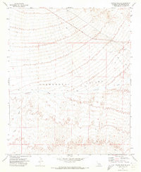
1971 Map of Savahia Peak NE
USGS Topo · Published 1973About this map
The Chemehuevi Valley defines the topography of this Mojave Desert reach in the early 1970s. The landscape is dominated by the broad drainage of the Chemehuevi Wash, which trends toward the east through the center of the sheet. The arid character of the region is reflected in the prevalence of dry watercourses like Gary Wash and the sparse network of unimproved desert transit. Mapping here captures a moment when travel across the valley floor relied heavily on a primary Jeep Trail and the diagonal corridor of Havasu Lake Road. These routes suggest the historical pattern of access and movement through the California desert before more modern infrastructure or recreational developments altered the remote valley floor.
Find a feature on this map
5 named features on this map. Tap any name to fly to it.
Don’t see what you’re looking for? This feature index may not catch every label — zoom into the map to look around manually.
Map Details
Editions of this 1971 Savahia Peak NE Map
2 editions found
Other maps of this area

1903 · Needles
USGS Topo · 1:125,000

1904 · Needles Special
USGS Topo · 1:125,000

1911 · Parker
USGS Topo · 1:125,000

1943 · Topock
USGS Topo · 1:62,500

1943 · Whipple Mts.
USGS Topo · 1:62,500

1950 · Topock
USGS Topo · 1:62,500

1950 · Sawtooth Range
USGS Topo · 1:62,500

1950 · Whipple Mts
USGS Topo · 1:62,500

1950 · Savahia Peak
USGS Topo · 1:62,500

1951 · Topock
USGS Topo · 1:62,500