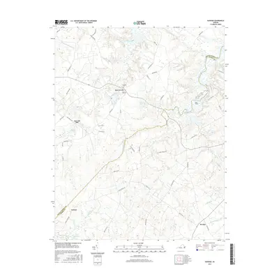
2016 Map of Savedge
USGS Topo · Published 2016About this map
Burrowsville serves as a central hub in this Tidewater landscape where the boundaries of Prince George and Surry counties meet. The area is defined by its intricate drainage systems, where Wards Creek and Upper Chippokes Creek carve through the coastal plain toward the James River. Local history is anchored by sites like the Lone Oak Mill and the Brandon Cem, reflecting a long-standing rural economy rooted in milling and agriculture. Numerous millponds and swamps, including Low Point Millpond, Avery Millpond, and the broad reaches of Cypress Swamp, illustrate how water management has shaped land use and property lines over generations. Smaller settlements like Savedge and Barham are connected by a network of named country roads such as Fort Powhatan Rd and Wards Creek Rd, which follow the natural contours of the low-lying terrain.
Find a feature on this map
53 named features on this map. Tap any name to fly to it.
Don’t see what you’re looking for? This feature index may not catch every label — zoom into the map to look around manually.
Map Details
Editions of this 2016 Savedge Map
This is the sole edition of this map. No revisions or reprints were ever made.
Other maps of this area

1917 · Toano
USGS Topo · 1:62,500

1918 · Charles City
USGS Topo · 1:62,500

1918 · Toano
USGS Topo · 1:62,500

1919 · Surry
USGS Topo · 1:62,500

1919 · Disputanta
USGS Topo · 1:62,500

1943 · Savedge
USGS Topo · 1:31,680

1943 · Disputanta
USGS Topo · 1:31,680

1943 · Richmond
USGS Topo · 1:250,000

1944 · Waverly
USGS Topo · 1:31,680
1944 · Nebletts Mill
USGS Topo · 1:31,680