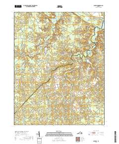
2019 Map of Savedge
USGS Topo · Published 2019About this map
Burrowsville and the surrounding Prince George County landscape are defined by the intricate hydrology of the James River drainage system. This survey illustrates a network of small agricultural settlements and family-named landmarks connected by rural arteries like James River Dr and Brandon Rd. The interior geography is dominated by extensive wetlands and meandering waterways, including Upper Chippokes Creek and Wards Creek, which carve through the terrain toward the river.
Find a feature on this map
54 named features on this map. Tap any name to fly to it.
Don’t see what you’re looking for? This feature index may not catch every label — zoom into the map to look around manually.
Map Details
Editions of this 2019 Savedge Map
This is the sole edition of this map. No revisions or reprints were ever made.
Other maps of this area

1917 · Toano
USGS Topo · 1:62,500

1918 · Charles City
USGS Topo · 1:62,500

1918 · Toano
USGS Topo · 1:62,500

1919 · Surry
USGS Topo · 1:62,500

1919 · Disputanta
USGS Topo · 1:62,500

1943 · Savedge
USGS Topo · 1:31,680

1943 · Disputanta
USGS Topo · 1:31,680

1943 · Richmond
USGS Topo · 1:250,000

1944 · Waverly
USGS Topo · 1:31,680
1944 · Nebletts Mill
USGS Topo · 1:31,680