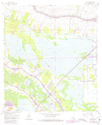
1963 Map of Savoie
USGS Topo · Published 1981About this map
Bayou Lafourche and Bayou Cut Off define the northern drainage patterns of this coastal landscape, where the boundary between Lafourche Parish and Terrebonne Parish snakes through a complex network of waterways. The settlement of Savoie sits at the heart of this system, surrounded by evidence of mid-century industrial growth including the Lafourche Crossing Oil and Gas Field and several drill holes. Local spiritual and community life is anchored by landmarks such as St Louis Chapel, Immaculate Heart of Mary Ch, and the Coteau Mission. Much of the southern terrain consists of wetlands like Grand Bayou and Folse Bayou, areas that were undergoing significant change at the time of this survey, evidenced by sections marked Under Construction and the expansion of the Houma Gas Field.
Find a feature on this map
36 named features on this map. Tap any name to fly to it.
Don’t see what you’re looking for? This feature index may not catch every label — zoom into the map to look around manually.
Map Details
Editions of this 1963 Savoie Map
4 editions found
Other maps of this area

1892 · Lac Des Allemands
USGS Topo · 1:62,500

1892 · Gibson
USGS Topo · 1:62,500

1892 · Houma
USGS Topo · 1:62,500

1892 · Thibodaux
USGS Topo · 1:62,500

1897 · Gibson
USGS Topo · 1:62,500

1932 · Houma SE
USGS Topo · 1:31,680

1932 · Lac Des Allemands SE
USGS Topo · 1:31,680

1932 · Lac Des Allemands SW
USGS Topo · 1:31,680

1932 · Houma SW
USGS Topo · 1:31,680

1932 · Houma NE
USGS Topo · 1:31,680