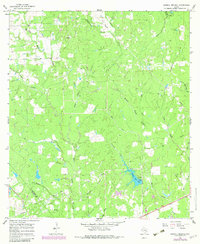
1965 Map of Sawmill Branch
USGS Topo · Published 1983About this map
The confluence of various tributaries of the Sandy Creek system defines this landscape in southeast Texas during the mid-1960s. West Sandy Creek, Middle Sandy Creek, and East Sandy Creek create a complex drainage pattern through the woodland and pasture, complemented by smaller waterways like Sawmill Branch and Alligator Branch. A notable human-made landmark in this rural expanse is Crooked Creek Lake, complete with its spillway, which represents a significant water management feature for the era.
Find a feature on this map
20 named features on this map. Tap any name to fly to it.
Don’t see what you’re looking for? This feature index may not catch every label — zoom into the map to look around manually.
Map Details
Editions of this 1965 Sawmill Branch Map
2 editions found
Other maps of this area

1919 · Schulenburg
USGS Topo · 1:62,500

1953 · Seguin
USGS Topo · 1:250,000

1956 · Glidden
USGS Topo · 1:62,500

1957 · Columbus
USGS Topo · 1:24,000

1957 · Borden
USGS Topo · 1:24,000

1958 · Seguin
USGS Topo · 1:250,000

1962 · Sublime
USGS Topo · 1:24,000

1965 · Oakland
USGS Topo · 1:24,000

1965 · Sawmill Branch
USGS Topo · 1:24,000

1965 · Rock Island
USGS Topo · 1:24,000