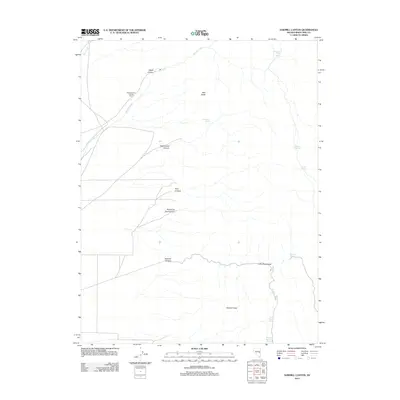
2012 Map of Sawmill Canyon
USGS Topo · Published 2012About this map
Sawmill Peak anchors this high-desert terrain of eastern Nevada, where the drainage patterns of the Egan Range dictate the location of ranching infrastructure and seasonal water sources. The presence of the Water Canyon Holding Corral reflects the ongoing cattle-working heritage of the region, situated along the base of the mountains where Martins Creek flows out from Water Canyon.
Find a feature on this map
19 named features on this map. Tap any name to fly to it.
Don’t see what you’re looking for? This feature index may not catch every label — zoom into the map to look around manually.
Map Details
Editions of this 2012 Sawmill Canyon Map
This is the sole edition of this map. No revisions or reprints were ever made.
Other maps of this area

1952 · Ely
USGS Topo · 1:125,000

1956 · Lund
USGS Topo · 1:250,000

1956 · Ely
USGS Topo · 1:250,000

1958 · Ely
USGS Topo · 1:62,500

1959 · Ely
USGS Topo · 1:250,000

1959 · Preston Reservoir
USGS Topo · 1:62,500

1960 · Lund
USGS Topo · 1:250,000

1963 · Ely
USGS Topo · 1:250,000
1973 · White Rock Creek
USGS Topo · 1:24,000
1977 · Bullwhack Summit
USGS Topo · 1:24,000