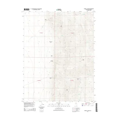
2014 Map of Sawmill Canyon
USGS Topo · Published 2014About this map
Sawmill Peak dominates the southern reaches of the Egan Range, overlooking a complex system of drainage and seasonal water sources in this part of White Pine County. The landscape is defined by its namesake timber and milling history, evidenced by the cluster of labels including Sawmill Canyon, Sawmill Spring, Second Sawmill Spring, and Fourth Sawmill Spring. These features suggest a legacy of early industry or settlement supported by high-elevation hydrology. To the north, the terrain transitions into deep-cut topographic features such as Water Canyon and Cottonwood Canyon, while isolated landmarks like Red Butte and the curiously named Mahogany Hotel Spring provide specific points of interest for researchers tracking historical land use. The presence of numerous named springs, from Millard Spring to Lone Pine Spring, highlights the critical importance of water access in this high-desert environment.
Find a feature on this map
23 named features on this map. Tap any name to fly to it.
Don’t see what you’re looking for? This feature index may not catch every label — zoom into the map to look around manually.
Map Details
Editions of this 2014 Sawmill Canyon Map
This is the sole edition of this map. No revisions or reprints were ever made.
Other maps of this area

1952 · Ely
USGS Topo · 1:125,000

1956 · Lund
USGS Topo · 1:250,000

1956 · Ely
USGS Topo · 1:250,000

1958 · Ely
USGS Topo · 1:62,500

1959 · Ely
USGS Topo · 1:250,000

1959 · Preston Reservoir
USGS Topo · 1:62,500

1960 · Lund
USGS Topo · 1:250,000

1963 · Ely
USGS Topo · 1:250,000
1973 · White Rock Creek
USGS Topo · 1:24,000
1977 · Bullwhack Summit
USGS Topo · 1:24,000