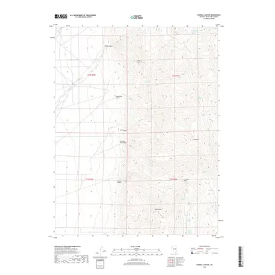
2018 Map of Sawmill Canyon
USGS Topo · Published 2018About this map
The Egan Range dominates this portion of White Pine County, where high-elevation terrain is marked by a network of drainage canyons and scattered mountain springs. The land is defined by prominent peaks and ridges, most notably Sawmill Peak and the nearby Red Butte. Water sources are vital landmarks in this arid high-country environment, evidenced by the numerous named springs such as Mahogany Hotel Spring, Cottonwood Spring, and Millard Spring.
Find a feature on this map
23 named features on this map. Tap any name to fly to it.
Don’t see what you’re looking for? This feature index may not catch every label — zoom into the map to look around manually.
Map Details
Editions of this 2018 Sawmill Canyon Map
This is the sole edition of this map. No revisions or reprints were ever made.
Other maps of this area

1952 · Ely
USGS Topo · 1:125,000

1956 · Lund
USGS Topo · 1:250,000

1956 · Ely
USGS Topo · 1:250,000

1958 · Ely
USGS Topo · 1:62,500

1959 · Ely
USGS Topo · 1:250,000

1959 · Preston Reservoir
USGS Topo · 1:62,500

1960 · Lund
USGS Topo · 1:250,000

1963 · Ely
USGS Topo · 1:250,000
1973 · White Rock Creek
USGS Topo · 1:24,000
1977 · Bullwhack Summit
USGS Topo · 1:24,000