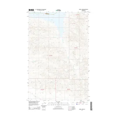
2014 Map of Sawmill Creek
USGS Topo · Published 2014About this map
Fort Peck Lake dominates the northern horizon of this Garfield County landscape, where the waters of the Missouri River meet the intricate drainage systems of the Missouri Breaks. The topography is defined by a network of seasonal and perennial streams that have carved deep into the high plains. Major watercourses like Big Coulee Cr and the winding Seven Blackfoot Cr dictate the movement of the land, while the bifurcated headwaters of N Sawmill Creek and S Sawmill Creek converge into the main channel of Sawmill Creek. This 2014 survey documents the rugged interface between the vast reservoir and the traditional ranching lands of central Montana. The map provides a clear record of the boundary between Phillips and Garfield Counties as it crosses the water, illustrating the intersection of natural hydrology and political geography in this sparsely populated region.
Find a feature on this map
13 named features on this map. Tap any name to fly to it.
Don’t see what you’re looking for? This feature index may not catch every label — zoom into the map to look around manually.
Map Details
Editions of this 2014 Sawmill Creek Map
This is the sole edition of this map. No revisions or reprints were ever made.
Other maps of this area

1954 · Jordan
USGS Topo · 1:250,000

1956 · Jordan
USGS Topo · 1:250,000

1958 · Jordan
USGS Topo · 1:250,000

1964 · Jordan
USGS Topo · 1:250,000

1965 · Spring Creek School
USGS Topo · 1:24,000

1965 · Pine Grove School
USGS Topo · 1:24,000

1965 · Schuyler Butte
USGS Topo · 1:24,000

1971 · Wolfe Coulee
USGS Topo · 1:24,000

1971 · Sawmill Creek
USGS Topo · 1:24,000

1971 · Chalk Butte
USGS Topo · 1:24,000