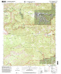
1995 Map of Sawmill Mountain
USGS Topo · Published 2000About this map
San Andreas Rift Zone geology and high-altitude forest ecosystems define this mid-1990s survey of the intersection between Kern and Ventura counties. The residential enclave of Pine Mountain Club is depicted in detail, featuring its golf course and network of mountain roads including Cerro Noroeste Road and the Potrero Highway. This period of forest management is reflected in infrastructure like the Apache Saddle Fire Station and multiple Communication Sites atop the peaks.
Find a feature on this map
31 named features on this map. Tap any name to fly to it.
Don’t see what you’re looking for? This feature index may not catch every label — zoom into the map to look around manually.
Map Details
Editions of this 1995 Sawmill Mountain Map
This is the sole edition of this map. No revisions or reprints were ever made.
Other maps of this area

1903 · Mt. Pinos
USGS Topo · 1:125,000

1942 · Eagle Rest Peak
USGS Topo · 1:24,000

1943 · Apache Canyon
USGS Topo · 1:24,000

1943 · San Guillermo
USGS Topo · 1:24,000

1943 · Sawmill Mountain
USGS Topo · 1:24,000

1943 · Santiago Creek
USGS Topo · 1:24,000

1943 · Cuddy Valley
USGS Topo · 1:24,000

1943 · Lockwood Valley
USGS Topo · 1:24,000

1943 · Reyes Peak
USGS Topo · 1:24,000
1944 · San Guillermo
USGS Topo · 1:31,680