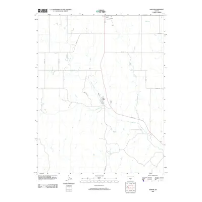
2009 Map of Sawyer
USGS Topo · Published 2009About this map
Sawyer stands at the northern edge of this Pratt County landscape, where the agricultural grid meets the winding tributaries of the Medicine Lodge River. The settlement of Elm Mills serves as a focal point further south, situated near the confluence where North Elm Creek and South Elm Creek join to form Elm Creek. This hydrographic network is the defining characteristic of the terrain, with additional drainages like Crooked Creek and Amber Creek cutting across the section lines. Transportation in the area relies on a mix of local routes such as Turkey Lane Rd and Mingona Rd, alongside the primary corridor of US Hwy 281. The map reveals a rural landscape structured by section-line roads, yet punctuated by the irregular paths of these creeks, reflecting a long history of cattle ranching and farming in south-central Kansas.
Find a feature on this map
20 named features on this map. Tap any name to fly to it.
Don’t see what you’re looking for? This feature index may not catch every label — zoom into the map to look around manually.
Map Details
Editions of this 2009 Sawyer Map
This is the sole edition of this map. No revisions or reprints were ever made.
Other maps of this area

1891 · Medicine Lodge
USGS Topo · 1:125,000

1892 · Pratt
USGS Topo · 1:125,000

1893 · Medicine Lodge
USGS Topo · 1:125,000

1894 · Pratt
USGS Topo · 1:125,000

1955 · Pratt
USGS Topo · 1:250,000

1959 · Pratt
USGS Topo · 1:250,000

1968 · Pratt SW
USGS Topo · 1:24,000

1968 · Coats
USGS Topo · 1:24,000
1968 · Pratt SE
USGS Topo · 1:24,000
1973 · Sun City NE
USGS Topo · 1:24,000